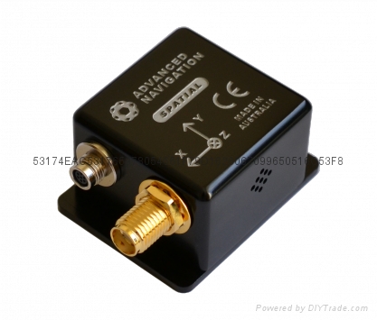
BDUNISTAR
Product Catalog
Technical support
Partners
Hiring
company news
Custom Topic
News

Product Catalog 

Spatial GNSS/INS

  • Spatial   GNSS/INS
  • Spatial   GNSS/INS
  • Spatial   GNSS/INS
  • Spatial   GNSS/INS
  • Spatial   GNSS/INS
  • Spatial   GNSS/INS
  • Spatial   GNSS/INS
  • Spatial   GNSS/INS
  • Spatial   GNSS/INS
  • Spatial   GNSS/INS
  • Spatial   GNSS/INS
  • Spatial   GNSS/INS
  • Spatial   GNSS/INS
  • Spatial   GNSS/INS
  • Spatial   GNSS/INS
Model No.︰spatail
Brand Name︰ADVANCEDNAVIGATION
Country of Origin︰Australia
Unit Price︰CNY ¥ 28000 / pc
Minimum Order︰1 pc
Share on:

 Total 2 Related Items 
Prev12

Product Description


SPATIAL

Spatial is a ruggedized miniature GPS aided inertial navigation system and AHRS that provides accurate position, velocity, acceleration and orientation under the most demanding conditions. It combines temperature calibrated accelerometers, gyroscopes, magnetometers and a pressure sensor with an advanced GNSS receiver. These are coupled in a sophisticated fusion algorithm to deliver accurate and reliable navigation and orientation.

CALIBRATED DYNAMIC RANGING SENSORS

Spatial contains very high performance MEMs inertial sensors. These are put through Advanced Navigation's intensive calibration process to increase their performance further still and provide consistently accurate data over an extended temperature range of -40°C to 85°C. Advanced Navigation's custom calibration process is the only full sensor calibration that can provide dynamic ranging, allowing the user to select a sensor range for high accuracy or high accelerations on the fly. As part of this calibration, every Spatial unit spends 8 hours in our specially built rotating temperature chamber.

MULTI CONSTELLATION GNSS

Spatial's next generation GNSS receiver supports all of the current and future satellite navigation systems including GPS, GLONASS, GALILEO and BeiDou. These additional satellite constellations allow Spatial to provide accurate position and velocity data in environments where GPS only units can't, such as urban canyons and indoors. When Spatial can't get a satellite fix, it continues to navigate using inertial navigation.

ADVANCED FILTER

Spatial contains Advanced Navigation's revolutionary sensor fusion filter. The filter is more intelligent than a typical extended kalman filter and is able to extract significantly more information from the data by making use of human inspired artificial intelligence. It was designed for control applications and has a high level of health monitoring and instability prevention to ensure stable and reliable data.

MINIATURE RUGGED ENCLOSURE

Spatial's precision marine grade aluminium enclosure is waterproof and dirtproof to the IP67 standard and shockproof to 2000g, allowing it to be used in the most extreme conditions. A sophisticated venting system allows the unit to measure air pressure whilst keeping water out. Its minimal size, weight and power requirements allow for easy integration into almost any system.

HOT START

Spatial contains a next generation battery backup system that allows it to hot start inertial navigation from its last position in 500 milliseconds and obtain a GNSS fix in approximately 3 seconds. The battery backup system lasts for the lifetime of the product and will provide backup for 48 hours without power. Spatial is the first GNSS/INS in the world to provide hot start navigation. Advanced Navigation's Spatial series are the only GNSS/INS in the world to provide hot start inertial navigation.

RELIABILITY

Spatial has been designed from the ground up for mission critical control applications where reliability is very important. It is built on top of a safety oriented real time operating system and all software is designed and tested to safety standards with fault tolerance in mind. The hardware is protected from reverse polarity, overvoltage, surges, static and short circuits on all external interfaces. The GNSS contains RAIM, which excludes both malfunctioning, and tampered satellite signals.

HIGH UPDATE RATE

Spatial's internal filter runs at 1000Hz and data can also be output at this rate over high speed RS232. This allows for control of dynamically unstable platforms. Spatial is also highly tolerant of dynamic movement and vibration with a very advanced custom navigation filter.

PERIPHERALS

Spatial features two general purpose input output pins that support an extensive number of peripherals. Including odometer based input for ground vehicles, RTK GPS systems, DVLs and USBLs for underwater navigation, NMEA input/output and more. For an integration fee, custom peripheral devices can be added.


specifications︰NAVIGATION
Horizontal Position Accuracy 2.0 m
Vertical Position Accuracy 3.0 m
Horizontal Position Accuracy
(with DGNSS) 0.6 m
Vertical Position Accuracy
(with DGNSS) 1.0 m
Velocity Accuracy 0.05 m/s
Roll & Pitch Accuracy
(Static) 0.1 °
Heading Accuracy
(Static) 0.5 °
Roll & Pitch Accuracy
(Dynamic) 0.2 °
Heading Accuracy
(Dynamic with GNSS) 0.2 °
Heading Accuracy
(Dynamic, Magnetic Only) 0.8 °
Heave Accuracy 5 % or 0.05 m
(whichever is greater)
Orientation Range Unlimited
Hot Start Time 500 ms
Internal Filter Rate 1000 Hz
Output Data Rate Up to 1000 Hz
Latency 0.4 ms
SENSORS
Sensor Accelerometers Gyroscopes Magnetometers Pressure
Range
(Dynamic) 2 g
4 g
16 g
250 °/s
500 °/s
2000 °/s
2 G
4 G
8 G
10 to 120 KPa
Bias Instability 20 ug 3 °/hr - 10 Pa
Initial Bias < 5 mg < 0.2 °/s - < 100 Pa
Initial Scaling Error < 0.06 % < 0.04 % < 0.07 % -
Scale Factor Stability < 0.06 % < 0.05 % < 0.09 % -
Non-linearity < 0.05 % < 0.05 % < 0.08 % -
Cross-axis Alignment Error < 0.05 ° < 0.05 ° < 0.05 ° -
Noise Density 150 ug/√Hz 0.005 °/s/√Hz 210 uG/√Hz 0.56 Pa/√Hz
Bandwidth 400 Hz 400 Hz 110 Hz 50 Hz
GNSS
Model u-blox M8
Supported Navigation Systems GPS L1
GLONASS L1
GALILEO E1
BeiDou L1
Supported SBAS Systems WAAS
EGNOS
MSAS
GAGAN
QZSS
Update Rate 10 Hz
Cold Start Sensitivity -148 dBm
Tracking Sensitivity -167 dBm
Hot Start First Fix 1 s
Cold Start First Fix 26 s
Horizontal Position Accuracy 2.5 m
Horizontal Position Accuracy
(with SBAS) 1 m
Velocity Accuracy 0.05 m/s
Timing Accuracy 30 ns
Acceleration Limit 4 g
COMMUNICATION
Interface RS232
Speed 4800 to 1M baud
Protocol AN Packet Protocol or NMEA
Peripheral Interface 2x GPIO and Auxiliary RS232
GPIO Level 5 - 20 V
GPIO Functions 1PPS
Odometer
Stationary
Pitot Tube
NMEA input/output
Novatel GNSS input
Trimble GNSS input
AN Packet Protocol input/output
Packet Trigger Input
Event Input
HARDWARE
Operating Voltage 5 to 36 V
Input Protection ±40 V
Power Consumption
(Typical) 0.5 W
Hot Start Battery Capacity > 48 hrs
Hot Start Battery Charge Time 30 mins
Hot Start Battery Endurance > 10 years
Operating Temperature -40 °C to 85 °C
Environmental Protection IP67
MIL-STD-810G
MTBF 310,000 hrs
Shock Limit 2000 g
Dimensions
(excluding tabs) 30x30x24 mm
Dimensions
(including tabs) 30x40.6x24 mm
Weight 37 grams
Advantages︰SURVEYING


Spatial's high accuracy roll, pitch and heading make it well suited for surveying applications. It supports DGNSS which gives it significantly enhanced positioning accuracy over standard GPS. The system supports connection of a high resolution wheel speed sensor or odometer which allows it to maintain accurate data through GPS outages and continue surveys through tunnels and other areas where GPS signals are not available.

UNMANNED AERIAL VEHICLES


Spatial is very popular on unmanned aerial vehicles. Its high accuracy orientation allows it to be used both for control and georeferencing. It supports a range of pitot tubes and air data units which allows it to maintain high accuracy positioning for hours without GPS. It supports both SBAS and ground transmitted differential corrections for increased GPS positional accuracy. It's low size, weight and power consumption allows for easy integration into even the smallest UAVs.

ROBOTICS


Spatial’s accurate orientation data allows for stabilization of robotic systems and its position, velocity and acceleration data can be used for robot navigation. Spatial’s high update rate allows it to control dynamically unstable platforms and its focus on safety and reliability provides for piece of mind.

MARINE


Spatial is ideal for use in marine applications providing accurate positioning, heading, heel, trim and heave. Its rugged design stands up to tough conditions at sea. Its magnetic heading is calibrated for hard and soft iron using an advanced ellipsoid algorithm and can provide both true heading and magnetic heading using its built in world magnetic model.

MOTORSPORT


Spatial is an excellent tool for performance measurement in motorsport. From the velocity and orientation data, slip, oversteer and understeer can be calculated. The velocity and acceleration data can be used to calculate improvements to braking and accelerating. Position can be used to determine the deviation from the optimum track position. Spatial’s high vibration tolerance and dynamic range means there are no concerns about engine or road vibration. Spatial also supports data output to data acquisition systems such as Dewesoft products.

TRACKING AND SECURITY


Spatial’s GNSS RAIM satellite verification, high sensitivity and multiple constellations make it difficult for thieves to spoof. Even if GNSS is lost, Spatial can continue to accurately navigate on its other sensors indefinitely when a vehicle odometer input is attached. Its backup memory means that cutting the power will not lose its position either. This makes it an excellent choice for tracking and security where it is nearly impossible for thieves to circumvent.
Product Image


Related Products
ORIENTUS
ORIENTUS
CNY ¥ 9800


BDUNISTAR  |  Product Catalog  |  Technical support  |  Partners  |  Hiring  |  company news  |  Custom Topic  |  News  |  Sitemap  |  Mobile Version
  简体版     繁體版     English

Powered by DIYTrade.com  Build your FREE website !
Find Best Price For China Products !